Banner image placeholder
Banner image

Maheshwaram irrigated basin


Multi-scale understanding of a heavily exploited crystalline aquifer, showing how weathering and sub-horizontal fracturing control aquifer architecture and groundwater flow, how monsoon rainfall recharges the system, and how intensive irrigation pumping drives long-term groundwater depletion.

🆔

Location: South of Hyderabad, Telangana state, India

Elevation: 590 - 670 masl

Geology: Crystalline rock basement (mainly granite)

Aquifer type: fractured crystalline-rock aquifer 

Scientific question: " How does groundwater circulate through the fractured crystalline basement? "

Maheshwaram has been part of  SNO H+ and OZCAR reserach infrastructure

Location map

(a) Maheshwaram watershed with location of pumping borewells for irrigation (July 2002), (b) EHP (0.55 km²) site near Choutuppal village, with two clusters of monitored borewells

Key findings

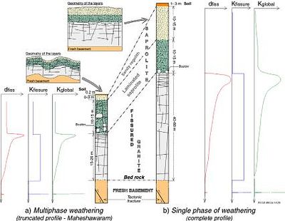
  • Aquifer architecture: the aquifer is organized into a weathered/saprolitic layer overlying a fractured granite layer, with the most transmissive zone near their interface and a network of predominantly sub-horizontal fractures.
  • Groundwater recharge and flow: stable isotopes showed that groundwater is mainly derived from present-day monsoon rainfall, with evaporation during infiltration through the soil and saprolite and spatially variable recharge.
  • Multi-scale characterization: combining boreholes, geophysics, hydraulic tests and groundwater-level monitoring made it possible to characterize the geometry and hydraulic properties of the heterogeneous weathered–fractured aquifer from the well to the catchment scale.
  • Impact of intensive pumping: long-term monitoring demonstrated a persistent decline in groundwater levels under intensive irrigation pumping, leading to the drying of springs and streams and progressively deeper water tables.
  • Groundwater management: the observatory provided a quantitative basis for estimating specific yield and recharge, assessing groundwater budgets, and developing management approaches for heavily exploited crystalline aquifers.

Hydrogeological model

(a) Conceptual hydrogeological model of crystalline rock aquifers (b).The box identifies the saturated weathered and fractured part of the aquifer with hydrodynamic properties..


An Observatory of Groundwater in Crystalline Rock Aquifers Exposed to a changing Environment : Hyderabad, India


Jean-Christophe Marechal, Adrien Selles, Benoit Dewandel, Alexandre Boisson, Jerome Perrin, Shakeel Ahmed

Vadose Zone Journal, vol. 17, 2018 Nov

Share

Text Only Owlstown
QR Code
Translate to